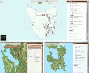
An on-going research project, headed by researchers at the University of New England has recently received the 2020 APSEA (Asia-Pacific Spatial Excellence Awards) award for Spatial Enablement. This project, called Convict Landscapes: Van Diemen’s Land, is an interactive digital tool that allows visitors to see the many places that convicts were incarcerated and laboured across Tasmania between 1804 and 1877.
This digital mapping tool gives more than a simple glance back in time, it provides insights into convict locations across time. With the tool anyone can see the various places in Tasmania (at the time called Van Diemen’s Land) that convicts inhabited according to their type, for example road gang, probations station and female factory. Other historical data is also included in the digital map, such as the progress of the road network over time.
“Receiving the award provides the project with recognition,” says UNE Postdoctoral Research Fellow Dr Richard Tuffin and member of the team working on the project. “Often the difficulty with research is actually getting eyes on the product – and sustaining interest. Awards such as this bring it to the attention of new people, who will look at the research and hopefully begin to engage with some of our other inputs.”
With the Van Diemen’s Land mapping tool winning the 2020 APSEA award for Spatial Enablement, this makes the second year in a row that the Convict Landscapes project has received this award, with the teams previous mapping project, the Port Arthur penal station 1830-77, winning in 2019. Find more information on the Port Arthur digital mapping tool here.
“Like our previous mapping project the mapping is designed to show change over a sequence of years via use of a time slider,” Richard says. “Places then appear or disappear according to their years of operation, showing the expansion and retraction of the convict system across the colony. All the data is downloadable through RUNE, meaning that other researchers and managers can utilise the coding and location systems built into the data.”
When discussing how this initiative came about, Dr Tuffin noted that it was a direct outcome of his team’s Australian Research Council-funded project Landscapes of Production and Punishment. Another important factor in the creation of this initiative has been the team’s collaborators – Esk Mapping & GIS.
“It’s a direct melding of historical and spatial research, which is something we really pushed during the wider project. A lot of historical research went into mapping every convict place in Tasmania (formerly Van Diemen’s Land).”
The mapping is designed to be a living research entity, updated as and when we find more information on a place, or find the location of a hitherto unknown operation.
Archaeological mapping may invoke imagery of digs and unearthing historic sites, but this mapping project was performed entirely from archival research and secondary sources.
“Some places were very easy to locate with a high degree of accuracy, others could only be located to an area – or not at all. All the work was undertaken in GIS (Geographic Information System), within which we could overlay historic maps and plans, as well as previous archaeological and heritage surveys, on modern imagery, helping us locate the sites.”
“This was then given to Esk Mapping & GIS, who turned it into the slick production that is presented on the website.”
While research is on-going and the project is still a work in progress, the digital map can be explored here: https://convictlandscapes.com.au/VDL/.


Recent Comments