I know, I know, it’s been a while since our last update (bar some crowing about recent media appearances). That’s because we’ve been busy. Obviously. Stop asking.
We’re busy because we’re in the final stages – the death throes – of the excavation. It’s been a wild ride, but all good things have to end. The end cometh on 13th August. We’re now madly (but with great care and paying attention to every single detail) trying to get the last of the foundry-period pits excavated (there are so many), try to disentangle any of the remnants of the earlier 1830s-40s period, as well as cut some slots through the site to understand how the land was reclaimed. Below is the latest run of photogrammetry, showing the site in all its confusing glory. The main contexts have been outlined for your edification and enjoyment. If you understand what is going on, please send me an email, because we’re at a loss.
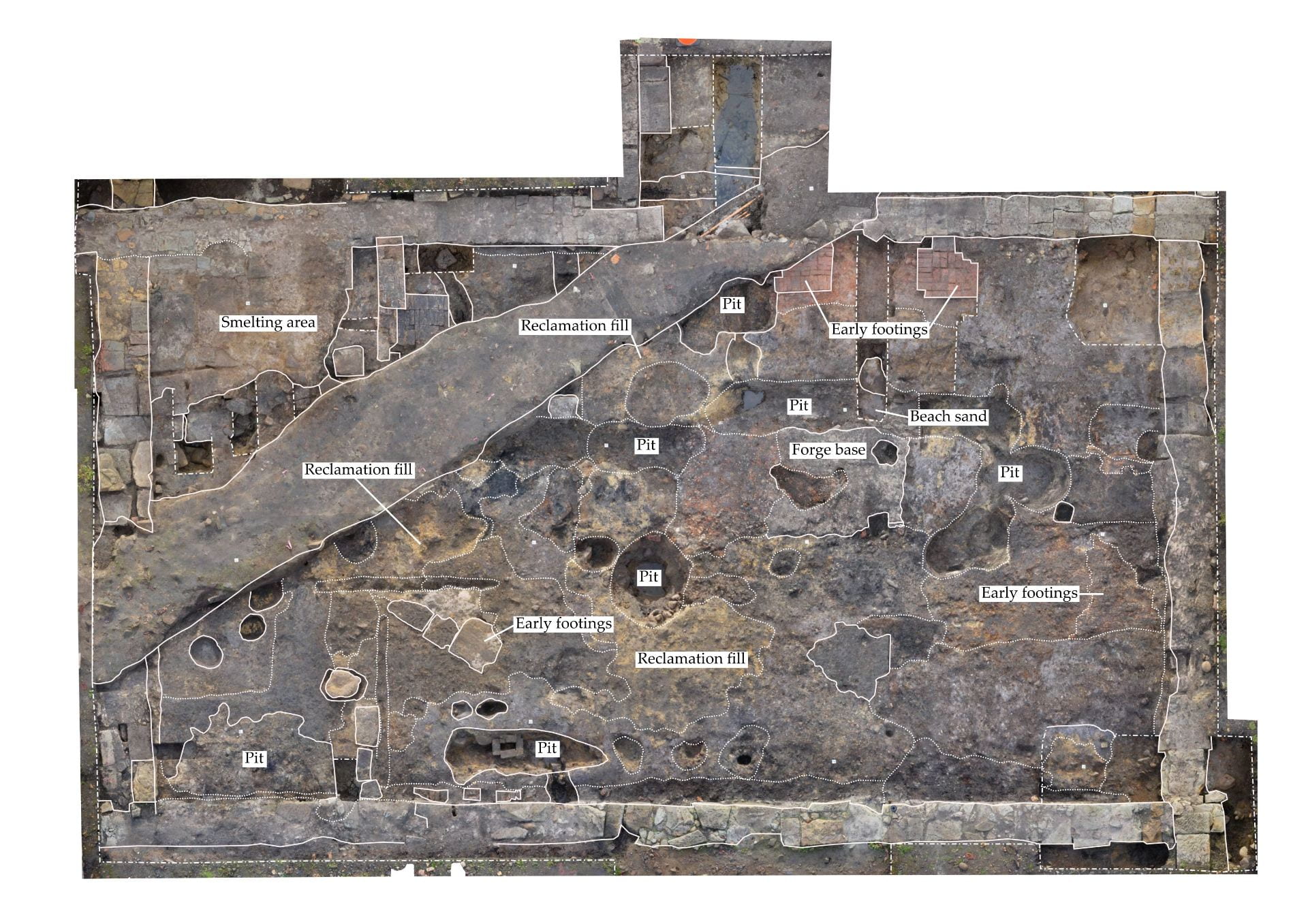
The latest photogrammetry. A more confusing mish-mash you will not find
What you’re looking at is an incredibly disturbed site, where the post-convict period has impacted the post-1850s foundry period, which in turn has drastically impacted upon the original deposits and features relating to the 1830s-40s shoemakers period – there’s even evidence for an intervening metal-working period (which does accord with some historical hints).
The west (to the left of image) of the site has been greatly impacted by the hydrant line (the diagonal strip of unexcavated soil). To the north (up) of this there is the intact flagged floor relating to the copper smelting area. South (down), we are still finding deep impacts from the 1850s-70s period, in the form of pits and intrusions potentially relating to some of the processes carried out in the area (vague enough for you?). There is an earlier sandstone and mortar footing placed at a 45 degree angle to the workshops range – this is potentially a feature relating to structures within the shoemakers workshops, or an even earlier building. In the centre most of the convict-period deposits have been scoured away, which is why the site is yellow – this is the reclamation clay and crushed sandstone. Again, there are a series of circular and linear pits – the purpose of which we are still determining. There are a couple of red brick ‘pads’, which are likely the earliest structures on the site, having been cut by the construction of the workshops’ northern footing. In a couple of slots we’ve also excavated down to the original beach sand – which is pretty cool. The clearest area of the site is the east (right), where we found compacted deposits of silt, charcoal and coal, relating to activity at the forge and associated with the anvil. These deposits covered some heavily disturbed brick surfaces, likely from the 1830s-40s.
It mightn’t be making much sense at the moment, but at least we still have our health.
As clear as mud Richard, but all very exciting. Actually, I exaggerate that is quite a clear piece of photogrammetry and deciphering! Excellent work!